The Moon Has a Secret History — And We’re About to Dig It Up
Here’s something that might surprise you: the most important real estate in the entire solar system right now isn’t on Earth. It’s a battered, crater-pocked patch of ground near the bottom of the Moon — and nobody has ever set foot there.
The lunar south pole looks, from space, like someone played the world’s most violent game of bumper cars for four billion years. Which, honestly, is pretty close to the truth. And yet, this chaotic, shadowy, geologically confused region is exactly where space agencies want to send the next humans to walk on the Moon. So before anyone takes a single step, scientists are doing something crucial: learning to read the Moon’s buried past like a history book.
Why the Moon’s South Pole Is Such a Big Deal
First, a little context. The Moon isn’t just a pretty thing to look at on a clear night. It’s a time capsule. Unlike Earth — where tectonic plates are constantly recycling the ground beneath our feet, and rain and wind erode everything away — the Moon has been mostly frozen in place for billions of years. Whatever happened to it, happened and stayed.
Think of Earth’s surface like an Etch A Sketch that gets shaken every few million years. The Moon’s surface is more like a drawing in concrete — every scratch and dent preserved exactly as it was made.
That means the craters, cliffs, and layers of rock at the lunar south pole aren’t just obstacles. They’re chapters in a story. A story about early solar system collisions, volcanic eruptions, and — here’s the really exciting part — the possible presence of water ice hiding in permanently shadowed craters that never see sunlight.
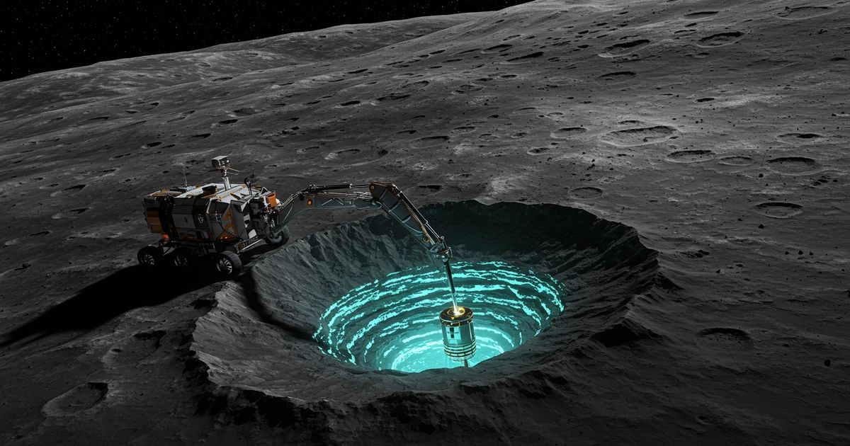
Water ice on the Moon isn’t just scientifically fascinating. It’s potentially rocket fuel. It could be drinking water. It could be the resource that makes long-term human presence on the Moon actually possible.
But before you can use any of it — before you can build anything, drill anything, or land anything safely — you have to understand what’s actually under the surface.
The Problem: It’s a Complete Mess Down There
Here’s the challenge. The lunar south pole isn’t just a little complicated. It’s arguably one of the most geologically scrambled places in the entire inner solar system — meaning the neighborhood of planets closest to the Sun.
Billions of years of asteroid and meteorite impacts have layered the ground like the world’s most chaotic lasagna. Ancient craters got filled in. Then new craters punched through those. Then debris from other impacts rained back down and buried everything under a fresh layer of rubble. Steep scarps — basically cliffs — jut out at odd angles. Slopes that look stable from orbit might be anything but.
And the deep darkness doesn’t help. Some craters near the south pole are in permanent shadow. The Sun never reaches their floors. No light means no traditional photography, no easy mapping, no quick answers.
So how do you read a history book when half the pages are buried and the lights are off?
What Scientists Are Actually Doing
This is where it gets clever. Researchers are combining multiple tools — like detectives using every clue available — to build up a picture of what lies beneath without ever physically digging.
One key technique involves radar. Scientists can bounce radio waves off the lunar surface and listen to how they echo back. Different materials — rock, ice, loose gravel — all reflect radio waves differently. Think of it like knocking on a wall to figure out if there’s something hollow behind it. A solid “thunk” versus a hollow “knock” tells you what’s there without tearing the wall down.
Another approach uses gravity measurements. Even from orbit, spacecraft can detect tiny variations in the Moon’s gravitational pull. Denser rock underground tugs a little harder on a passing satellite. In other words, scientists can literally feel what’s buried by measuring how it pulls on things flying overhead.
Then there’s seismic data — essentially, moonquakes. When the surface shakes (from impacts or internal shifts), the vibrations travel through the ground differently depending on what they pass through. It’s the same principle doctors use when they send sound waves through your body during an ultrasound. The echoes create a picture without anyone having to open anything up.
By layering all of these methods together, researchers are building something remarkable: a three-dimensional map of the south pole’s underground structure. Not perfect. Not complete. But far better than anything we’ve had before.
Why This Changes Everything
Understanding what’s underground might sound like an abstract scientific exercise. It is anything but.
Imagine you’re an engineer tasked with designing a habitat — a place where astronauts will actually live on the Moon. You need to know if the ground is stable enough to build on. You need to know where potential resources are. You need to know if that crater rim you’re planning to use as a landing site is solid ancient bedrock or a fragile pile of impact rubble held together by nothing but luck.
Getting that wrong isn’t an inconvenience. It’s a catastrophe.
This research is the essential groundwork — literally — for everything that comes next. Every landing site decision, every drilling operation, every resource extraction plan depends on understanding what’s actually down there. Scientists working on this aren’t just satisfying curiosity. They’re writing the instruction manual for humanity’s next chapter in space.
There’s also a deeper scientific prize. The Moon’s south pole may contain rocks and ice deposits that have been untouched for billions of years. Some of these permanently shadowed craters might hold frozen water delivered by ancient comets — water that existed before Earth’s oceans filled. Sampling that material could tell us things about the early solar system that no other place in the universe can reveal anymore.
In other words, the past is buried down there. And we’re getting close to being able to read it.
What Comes Next
The coming years are going to be extraordinary for lunar science. Multiple missions — robotic landers, orbiters with more powerful instruments, and eventually crewed expeditions — are all pointed at the south pole like arrows aimed at the same target.
Each one will add new data. Each measurement of underground structure, each radar echo, each gravity map will sharpen the picture a little more. Scientists expect surprises — geology almost always delivers them. There may be ice deposits larger than expected, or in stranger locations. There may be ancient lava tubes — underground tunnels left by long-extinct volcanic activity — that could serve as natural shelters for future astronauts.
And here’s the thought that should stick with you. Right now, the lunar south pole is one of the most mysterious and unexplored places in our solar system. Within a generation, humans might be living there. Walking across those crater rims, drilling into that ancient ice, reading that buried history in person.
Before any of that happens, though, we have to do the hard, quiet, unglamorous work of understanding the ground beneath our future footsteps. Scientists are doing exactly that — one radar pulse, one gravity measurement, one careful reading of a four-billion-year-old story at a time.
The Moon has been keeping its secrets for a long time. We’re finally close to hearing them.